Onick 360AS digital laser measurement and control system
Technical solution for digital laser measurement and control system for power sector/special for power sector, Onick 360AS digital measurement and control system, special for power sector, powerful, high acquisition, distance measurement, angle measurement, coordinate positioning area measurement, vehicle navigation and other functions in one.

*Windows mobile6.0 for pocket PC Chinese version operating system, 400MHZ high-speed processor
*Built-in high-sensitivity global satellite positioning module, GPS accuracy 3-5 meters
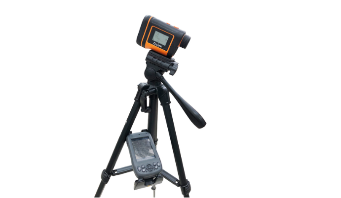
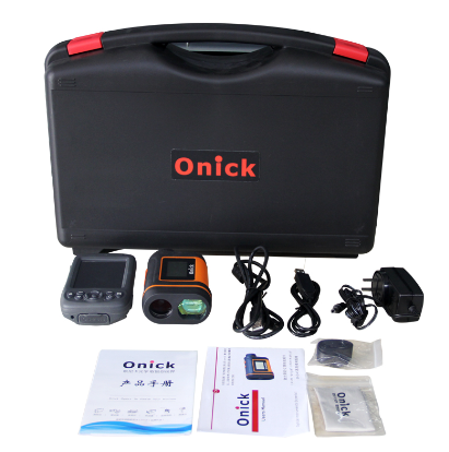
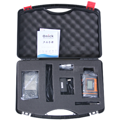
*Full configuration: laser rangefinder, GPSPDA receiver, vehicle power supply, data cable, vehicle bracket, charger
*Vehicle navigation, area measurement, mobile communication, digital photography, file editing, video browsing and other functions
The TM-300 handheld is a new generation of high-performance, rugged and durable handheld terminal designed for harsh working environments in the field. It integrates many first-class functions, is compact, rugged and affordable, and is suitable for the entire work team. The TM-300 handheld has the performance to resist harsh working environments, and its dust and water resistance level reaches IP65, which can adapt to users working in various environments and improve your outdoor experience.
The TM-300 integrates a variety of practical functions. It has a 5-megapixel digital camera, mobile phone communication, data transmission, electronic compass, barometric altimeter and 1-3 meters accurate fast GPS positioning. The large-capacity lithium battery can meet a day's field work and improve the productivity of the field team.
The TM-300's integrated 3G communication (optional WCDMA and EVDO) and wireless local area network (WLAN) provide high-speed Internet connection. The entire field team can quickly and reliably access the work order data, map data, reference files, and emails they need through the network, and retrieve and update task information in real time, thereby improving productivity and data accuracy.
LM-300 is a fully integrated solution with high cost performance and complete functions.

Product features:
1. Measurement without blind spots, dual display of data results
2. Distance measurement (horizontal distance, vertical distance, slant distance); tilt angle measurement (inclination and slope measurement)
3. Azimuth measurement, compensation measurement (three-point height measurement)
4. Span measurement between any two points in space
5. RS232 serial port data transmission or Bluetooth
6. Closest, farthest, multi-target continuous measurement mode
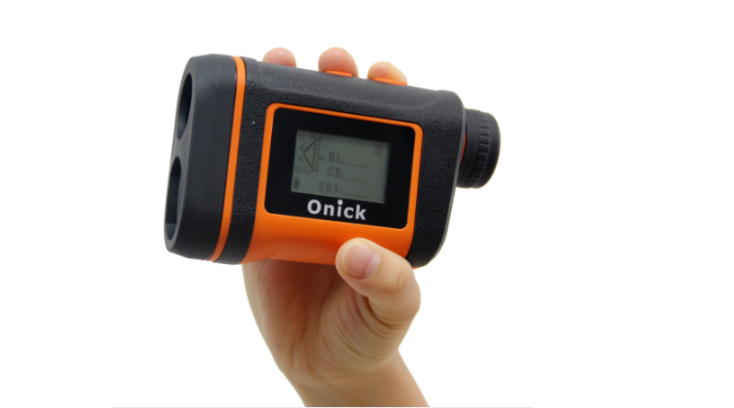
7. Vertical grip operation design, more convenient, suitable for daily use habits, durable and waterproof
Onick 360AS standard RS232 interface can transmit measurement data to PPC, data recorder, GPS receiver and other mobile devices. Optional Bluetooth function, easy to achieve real-time wireless data transmission. Can cooperate with GPS receiver for eccentricity measurement, and output the collected data to GPS in real time. The body is light and easy to carry, simple to operate, adopts vertical grip operation mode, sturdy design, waterproof and dustproof, it still integrates reflection-free, vertical angle sensor, electronic compass, measurement is faster, simpler, safer, more suitable for operation habits, making the instrument very suitable for field operations.

The functional advantages of Onick 360AS laser rangefinder and height meter are:
1) Vertical grip operation: closer to distance measurement and telescopic operation, more suitable for your measurement habits;
2) Ergonomic design, compact and lightweight, innovative lens coating, high light transmittance, making the observation effect clearer.
3) Azimuth can be measured, and single-point distance measurement, two-point span measurement, three-point height measurement and other functions can be performed: single-point measurement (SD/HD/VD/INC/AZ), two-point span measurement (ML), three-point height difference measurement (HT).
4) Three-dimensional space side measurement and span measurement can be performed: the straight-line distance (SD)/horizontal distance (HD)/vertical distance (VD)/inclination angle (INC) (or slope)/azimuth (AZ) and other parameters between any two invisible points in space can be directly measured and read data;
Specifications:
Size: 126x79.5x44mm
Weight: 246g
Data communication: Serial, via wired RS232 (standard), Bluetooth communication
Power: 1200MA/H rechargeable lithium battery
Laser source: Class 1 eye-safe
Temperature range: -20°C to +40°C
Optics: 7x magnification (field of view 330 feet/1000 yards)
Display: Built-in and external LCD display
Units: feet, yards, meters and degrees
Tripod: 1/4 inch threaded hole (standard camera tripod)

Measuring range:
Distance: 0m-2000m, reflective target is up to 2,500 meters
Tilt: ±90 degrees
Azimuth: 0 to 359.9 degrees
Accuracy:
Distance: ±0.2m (within 300 meters), ±1m (outside 300 meters)
Tilt: ±0.25 degrees
Azimuth: ±1 degree
Measurement mode: Horizontal distance, vertical distance, slope distance and tilt angle (or percentage slope)
Flexible three-point height difference measurement program (automatically arranges height and low angles)
And two-point spatial wiring program
Target modes: standard, closest distance, farthest distance, continuous and filtered (reflector and foliage filter required) mode

